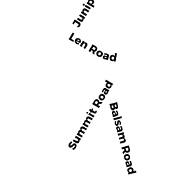
5 SUMMIT RD
Owner Information
HAYES PATRICIA A (CURTIS)
4 MEADOW STREET
NORWOOD, MA 02062


Property Details
5 SUMMIT RD is classified as a Undevelopable Residential Land.
5 SUMMIT RD is valued at $5,900. The land is valued at $5,900 and the structures are valued at $0.
This property is in Zone R3. Confirm with local Zoning Board authorities to ensure there are no overlays or other easements on this property.
The most recent deed for 5 SUMMIT RD is recorded at the local registrar in Book 5310, Page 460. 5 SUMMIT RD was last sold on Tuesday, March 1, 1977 for $0.
Assessment data from fiscal year 2018.
Flood Data
This property is partially within the AE Zone (within floodplain). Approximately 0.09 acres (78.62%) of the property is within this zone.
This information is sourced from the FEMA National Flood Hazard Layer. See our full disclamer.
Broadband Internet Providers
| Provider | Type | Bandwidth (mbps) | |
|---|---|---|---|
| Verizon New England Inc. | Fiber | 940 | 880 |
| VSAT Systems, LLC. | Satellite | 2 | 1 |
| HughesNet | Satellite | 25 | 3 |
| GCI Communication Corp. | Satellite | 0 | 0 |
| Viasat Inc | Satellite | 100 | 3 |
| Comcast | Cable | 1000 | 35 |
Broadband service provider data from December 2020.
Adjacent Properties
- 30 JUNIPER RD
Vacant, Selectmen or City Council (Municipal) owned by HOLBROOK TOWN OF - 28 JUNIPER RD
Developable Residential Land owned by FRYMORGEN TADEUSZ - 26 JUNIPER RD
Developable Residential Land owned by FRYMORGEN TADEUSZ - 3 SUMMIT RD
Undevelopable Residential Land owned by AMER CANCER SOC MASS DIVISION - 7 SUMMIT RD
Undevelopable Residential Land owned by PUSATERI JOAN